
Here's the view we had from our balcony at the resort. I think this was our first full day in Belize. From here you can see a white line along the horizon. Those are waves breaking on the reef, which is the second longest reef in the world and the first longest living. The reef breaks the waves so that by the time they reach the shore they just float in, rather than crash against the sand. Between the end of the dock and the reef is a highway for speedboats, which was our primary source of transportation for the week. Also here you can see a bunch of palms. It takes about 20 years for the trees to reach this height.

There were little lizards like this one all over the place...at the resort...at restaurants...in town...in the jungle. You name it.

This is us on the beach on a slightly rainy (but beautiful) day.
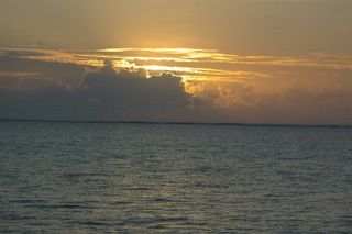
Sunrise in Belize, 5 a.m. precisely.

During sunrise a bunch of little fish were swimming near the dock so Kelly snapped some pictures of them. This is not with an underwater camera (those pictures will be developed later); the water was always this clear.

Us on a boat. Notice my hair flying about? Since we travelled usually by speedboat my hair was always pulled back and what could escape was always tangled and fuzzy.

On one of our speedboat excursions to get to a tour of the Belize mainland our boat had to pass through here. On either side are Mangrove trees that come up above forming a canopy.

Here's a better shot of the Mangrove trees. The roots are primarily exposed because they sit slightly above water. The limbs then grow roots that grow straight down toward the water from the limb. During the rainy season the water level raises about five feet, completely covering the roots.

This is the eastern freize of a Mayan ruin at Xunantunich (shoe-non-too-neech). We climbed this temple that was originally built only for royalty and priests.

Super cool pic of the two of us atop the temple at Xunantunich. This is 135 feet above plaza level. If you look over to the left you can see a road that (through the optical illusion of photography) runs right into my left side. This road creates the border between Belize and Guatemala. So there's actually two contries shown in this photograph!
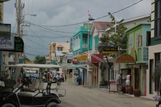
This is a typical street in San Pedro, the town on Amergris Caye (the island our resort was on). You may notice the bright colors of the buildings - this was common for all buildings as well as homes there. Also, dirt roads...their paving system isn't what you would call "good." Their main mode of transportation in the town (as opposed to between towns or resorts, which is by speedboat) is by bicycle or golf cart, both of which you can see here.
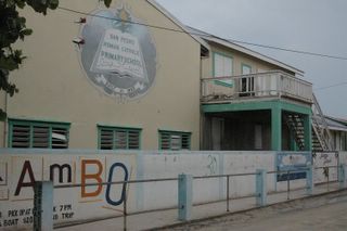
Here's one of the schools in San Pedro, called San Pedro Roman Catholic Primary School. Surprisingly, we saw a lot of schools - more than we had anticipated seeing. Even in some very small communities, we saw two or three schools. Children in all schools no matter the size of the community are taught both English and Spanish because those are the two national languages. Most of their schools are RC because that's the primary religion of the region. Their school operates on roughly the same calendar as here in America.

These are some school-aged girls in their school uniforms. All the schools in Belize require uniforms regardless of its status as either public or private. If your parents cannot afford to buy you a proper uniform, you cannot attend school.

More Mayan ruins...This is the Mask Temple at Lamanai. The guide said that whenever you see advertisements for Belize or Mayan ruins and there's a picture of a large face, you're looking at this ruin because this is the largest mask (on the right side) they have ever discovered. This mask is over five feet tall.

And because my blog is never complete without a picture of me and Kelly being cozy...

No comments:
Post a Comment